safety technology
3 technologies that drive safety innovation in site surveying
Over the past years, technology has played an increasingly important role in a wide variety of trades, including construction and surveying. New software and equipment is available more and more to enable automation and simulated environments in a way that was never possible before.
Here, we take a look at three significant technologies that have benefited and are now transforming many areas of activity within the surveying profession.
UAVs (Unmanned Aerial Vehicles)
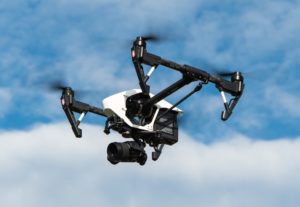
 You won’t have failed to notice that drones have, quite literally, taken off. The surveying industry has seen a significant uptake in the use of drone-related technology. These clever little flying objects have a multitude of uses to access hard-to-reach places. With the help of drones, surveyors can now carry out aerial surveys and daily investigations with relative ease and much greater efficiency. Using drones not only reduces the risk of injury to personnel but it also provides a more cost-effective solution for tasks that were previously laborious and time-consuming.
In particular, the mobility and verticality of drones mean that areas can now be inspected that were previously unsafe or impossible to reach. “Substantial improvements in camera drone technology in recent years means that it is now possible to take high-quality aerial photographs and high-resolution video footage to inspect building elements with astonishing accuracy,” explains Hutton + Rostron.
By using the device’s autonomous controls, the surveyor is able to programme the drone to automatically take a large aerial map of a particular site, then return to base and upload the data to a secure server. The increase in mobility as well as in automation saves time during the actual inspection. More than that, it allows the surveyor to collect several high-res images for future reference. In some cases, images can be collated into detailed, photorealistic 3D maps. Overall, the data can be interpreted through an incredibly accurate visual, which not only eliminates the need for excessive jargon, but also significantly reduces the risk of potential inaccuracies and inconsistencies.
Drones, it seems, are now considered so indispensable to the surveying world hat many firms have started to offer CPD training on drone use, though you also need a restricted or full CAA NQE qualification to be able to use a commercial drone.
AI (Artificial Intelligence)
There are several new technologies benefitting the surveying industry that are driven by Artificial Intelligence. Chief among them is Building Information Modelling (BIM), which provides a system to create a comprehensive digital description that is worked on collaboratively through each project stage. Exact 3D models contain a multitude of data that relate to each functional and physical element of the build.
As regards AI, these systems have already been influenced by the ability to infuse human intelligence with machine learning. For example, the analysis of vast amounts of data requires greater practical applications for QC assessments. And by employing theoretical techniques, Artificial Intelligence can quickly optimise the process and effectively predict and solve any logistical issues well in good time. This, in turn, results in substantial savings for the project before it gets to the build phase.
In the world of property surveying, combining Artificial Intelligence and Building Information Modelling has many important implications. Core responsibilities having been automated with BIM, surveyors can now focus on and carry out their day-to-day tasks more efficiently. By having access to a shared 3D visualisation of a site, for instance, process control and project management can be greatly enhanced.
AR (Augmented Reality)
 AR technology augments a live view of a physical environment with computer-generated input such as sound, video, graphics or GPS data. In the world of surveying and construction, this could mean the overlay of a BIM construction model on a particular ground site. “The goal is to enrich what the operator knows about the environment he is charting or working in, and to improve both work quality and time to decision for business benefit,” says an expert in the field.
The combination of 3D visualisations with AR creates effective reference resources for surveyors. What’s more, it can allow clients to see a realistic rendering of a building before it is actually constructed. This can be particularly useful for surveyors who assess future developments or buildings where repair works have been proposed but not yet carried out.
It is clear that the world of construction and property surveying is set to benefit hugely from advances in technology. The so-called Fourth Industrial Revolution will affect the industry in significant ways, and further reading on the topic should include this RICS Insight Report: The Impact of Emerging Technologies on the Surveying profession.
3 technologies that drive safety innovation in site surveying
Over the past years, technology has played an increasingly important role in a wide variety of trades, including construction and surveying. New software and equipment is available more and more to enable automation and simulated environments in a way that was never possible before.
Dakota Murphey
SHP - Health and Safety News, Legislation, PPE, CPD and Resources Related Topics
How will AI transform health and safety?
Drug and alcohol testing in a UK airport environment
New cladding fire risk identified and could be “tip of iceberg”
 You won’t have failed to notice that drones have, quite literally, taken off. The surveying industry has seen a significant uptake in the use of drone-related technology. These clever little flying objects have a multitude of uses to access hard-to-reach places. With the help of drones, surveyors can now
  AR technology augments a live view of a physical environment with computer-generated input such as sound, video, graphics or GPS data. In the world of surveying and construction, this could mean the overlay of a BIM construction model on a particular ground site. “The goal is to enrich what the operator knows about the environment he is charting or working in, and to improve both work quality and time to decision for business benefit,”